This season's El Nino effect, which has proved largely benign for agriculture so far, is expected to peak over the northern hemisphere winter.
But investors should keep a weather eye on the Pacific in the coming spring, to watch for a cooling pattern that could trigger droughts across key grain growing areas of the New World.
La Nina - "the girl" in Spanish - is a weather pattern caused by a dip in central and eastern Pacific temperatures, just as El Nino -"the boy" - is applied to a high temperature ocean pattern.
El Nino vs La Nina
El Nino is associated with higher rainfall in the Americas overall, but dryness in the western Pacific and the west coast of Africa.
| La Nina episodes following directly on from El Nino events, since 1980 El Nino La Nina 1982-83 1984-85 1987-88 1988-89 1994-95 1995-96 1997-98 1998-99 2006-07 2007-08 2009-10 2010-11 Source: US National Weather Service Climate Prediction Centre |
It also tends to bring cooler summers to the US, a boon, for example, to corn yield prospects - as seen indeed this year and in 2014 - with heat a setback to pollination, which occurs mainly in July.
But La Nina is broadly associated with the opposite weather effects, causing lower rainfall in the eastern Pacific, and higher rainfall in the western Pacific - and that can bring less favourable conditions to some major grain growing areas.
The drought year of 2012, when the US corn yield fell to a 17-year low of 123.4 bushels per acre, was an El Nino period.
As was 2008-09, when drought sent Argentine soybean production slumping by 30%.
Winter peak
The El Nino signal, as measured by ocean surface temperatures in the mid-Pacific, is expected to peak in December or January, and some models expect it to be one of the strongest on record.
This week the Australian Bureau of Meteorology said that the El Nino effect was expected to last into 2016, and was continuing to strengthen.
And La Ninas have a history of following hard on the heels of El Ninos, as ocean surface temperatures trend cooler.
Hotter, drier weather
US weather service Commodity Weather Group (CWG) noted that of the eight strong El Nino cases since 1950, the three strongest all transitioned rapidly to a La Nina summer, and the remainder were a split between neutral and La Nina summers....
...MORE
And today the Financial Times goes into more detail on the effects:
Looming La Niña cheers commodity bulls
Weather phenomenon may hit production affecting food prices
Move over El Niño — your sister is coming to town. From a weak Indian monsoon to excessive dryness in Southeast Asia, parts of the world have been hit by the strongest El Niño since 1997.
But meteorologists are now looking to 2016, where there is a strong possibility that the current weather phenomenon will swiftly transform into a La Niña — which tends to bring rainfall in Southeast Asia and Australia and dryness to the US midwest.
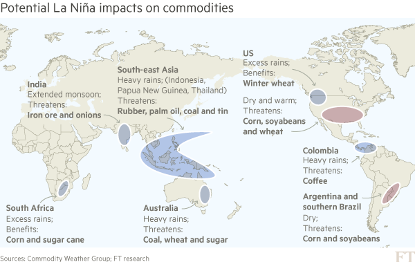
This may be good news for commodity bulls, as many agricultural raw materials have barely felt the effects of El Niño, caused by the warming of the tropical Pacific Ocean.
“Strong El Niños are much more likely to be followed by a La Niña,” says David Streit at consultancy Commodity Weather Group. The three strongest El Niños on record — in 1972, 1982 and 1997 — all transformed into La Niñas, he notes.
...MUCH MORE